Texas Offshore Miocene Project, Task 2
Regional Significance
Task 2 focuses on the regional geology of the Miocene age section in of Texas submerged lands and adjacent Federal OCS (Offshore Continental Shelf) lands. A major part of task is to generate a comprehensive dataset of formation characteristics and to produce an atlas of prospective sequestration “plays” by using a petroleum systems approach.
Hydrocarbon accumulation analysis of known Miocene oil and gas fields can provide specific, qualitative and quantitative analogue information on seal properties and fluid migration. Using the hydrocarbon ‘play’ concept, we have generated structure contour and isopach (net sand thickness) maps and cross-sections relevant for sequestration activities for a transect of Texas offshore lands. We have incorporated information for both prospective reservoir intervals as well as associated confining systems (seals) and have compiled a large GIS database from well data, production data, geophysical well logs, and 2-D and 3-D seismic surveys. This robust database allows us to fill in details within a large-scale framework.
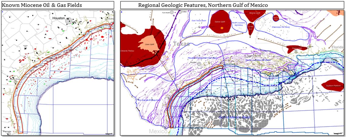
The figures above are maps generated from the database. The map on left shows all known major Miocene oil and gas fields (small accumulations are not shown) and the location of Texas State Waters Offshore CO2 Repository (orange outline). We have further subdivided these fields by hydrocarbon type, reservoir geologic age, trap type, and drive mechanism. Click on map to see larger image.
The map on right shows major regional geologic features in the northern Gulf of Mexico, with the following legend:
- Gray polygons: salt bodies
- Light cyan lines: 10m bathymetric contours to shelf edge (200m)
- Dark purple lines: major fault zones
- Light purple lines: individual faults
- Thick, blue dash-dot line: location of latest/last Miocene shelf margin (GBDS-Galloway)
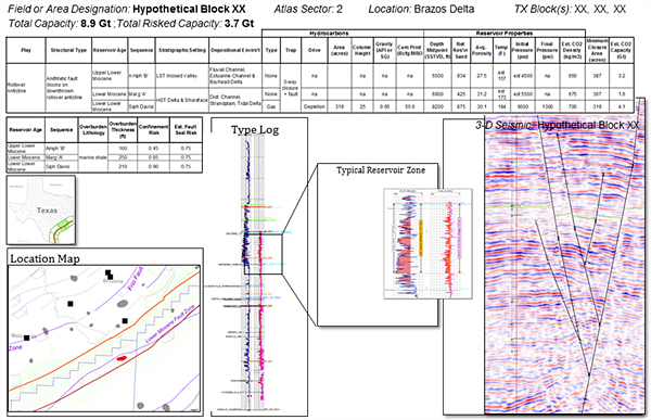
Using the data summarized in the two maps above and seismic-guided structural mapping, we are constructing a detailed quantitative and qualitative Miocene CO2 Play Atlas for Texas State Waters. The image below shows a mock-up of the kind of information in a Play Atlas for carbon sequestration. Important elements include:
- General location information
- Easily accessed capacity estimates
- Detailed reservoir properties
- Seal/confinement estimates
- Basic location and pertinent geologic maps (e.g., structure, isopach…)
- Type log
- Seismic and/or well-log cross section
In addition to using the databases for Play Atlas generation, we also use them to identify potential sites for carbon sequestration with capacities larger than 30 MT. Hydrocarbon Accumulation Analysis of known Miocene oil and gas fields can provide specific, qualitative and quantitative analogue information on seal properties and fluid migration.
The audience for the Play Atlas includes a broad spectrum of users, such as policy makers, industry executives, scientists and technical professionals, who would use the Atlas for a variety of strategic planning and screening purposes.
<< Back to Texas Offshore Miocene Project main page || view next Task >>


