SSEB Onshore and Offshore Georgia
Continued Evaluation of Potential for Geologic Storage of Carbon Dioxide in the Southeastern United States
2009–2011 Project Overview
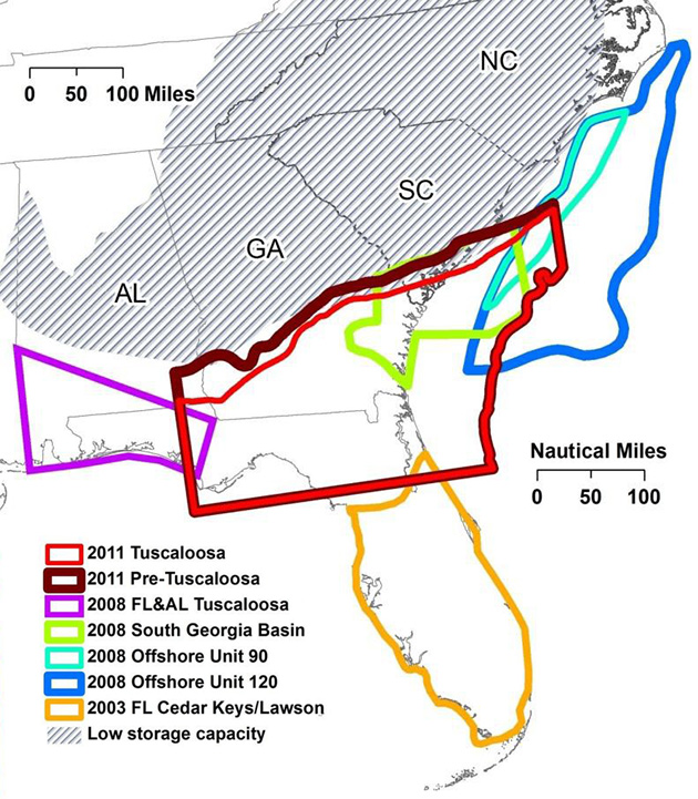
The need to reduce atmospheric emissions of carbon dioxide from industrial sources is now recognized internationally. As a result, companies operating coal-fired and other types of power plants in the southeastern U.S. have been seeking information on the potential for long-term storage of CO2 in nearby subsurface geologic formations. Previous studies have shown there to be little to no capacity for onshore subsurface storage of CO2 in deep saline reservoirs in the Carolinas and northern Georgia. However prior to this study, southern GA had not been assessed for geologic sequestration capacity potential. It is currently not known if extensive petroleum reserves exist below the continental shelf of the Atlantic Ocean offshore from SE US but potential offshore capacity for storage of CO2 is large.
The objectives of this study are
- assess the potential for GS of CO2 in areas of SE US not previously characterized (i.e. southern GA coastal plain between the panhandle of Florida (FL) and the Atlantic Ocean) and
- refine capacity estimates for portions of offshore geologic units present below the nearby Atlantic continental shelf.
We primarily focused on geographic areas where CO2 can be stored in deep saline reservoirs at depths great enough to keep it in supercritical phase, but also had to consider surrounding areas in order to better solve the geological puzzle. Maintaining CO2 in supercritical phase requires temperature greater than 31.1 °C (88 °F) and pressure greater than 7.39 MPa (72.9 atm), which corresponds to depth below ground surface of ~800 m (2600 ft). Results of this detailed study of the regional subsurface geologic units are timely for operators of coal-fired power plants in the SE US because technologies to separate, capture, and concentrate CO2 from industrial emissions are ready for commercial-scale demonstration. Two areas with thick accumulations of coastal plain sediment underlie the southwest and southeast GA embayments. It is in thicker sections of the embayments, both onshore and offshore, that nonmarine, clastic (i.e., gravel-, sand-, and silt-bearing) strata have the highest potential for deep geologic storage of CO2 generated in the SE US. To battle the complexity of Georgia's deep subsurface geology, we used the concepts of sequence stratigraphy to define the large-scale distribution of two potential CO2 geologic sequestration units. The sequence stratigraphic method focuses on tracing correlative time surfaces in cross sections that are made up of individual well logs and/or descriptions of rock core collected from wellbores. The advantage of the sequence stratigraphic method is that applied correctly, it captures architecture of rock units more accurately and at scales that affect subsurface fluid flow. After many iterations of correlation and cross section construction, the following major stratigraphic packages within our area of interest were identified:
- Pre-Tuscaloosa sandstones/conglomerates of upper Jurassic (?) to Early Cretaceous age
- Tuscaloosa (or equivalents) sandstones of early Late Cretaceous-age
- Post- Tuscaloosa sandstones and limestones of Late Cretaceous age The two intervals with sufficient thicknesses of net permeable clastic strata, at depths deep enough to store CO2 in supercritical phase, are Pre-Tuscaloosa and Tuscaloosa.

Estimates for the capacity of subsurface geologic units to store CO2 depend on, among other variables, the thickness of permeable sand present in a reservoir. We estimated CO2 storage capacity of the two GSUs by
- establishing geologic framework and determining porosity in Petra geologic modeling software
- exporting data to ArcGIS, and
- using methodology developed primarily by researchers at the Massachusetts Institute of Technology (MIT, 2010) and reported in the U.S. Department of Energy, National Energy Technology Laboratory National Carbon Sequestration Atlas (NETL, 2010) for saline reservoir capacity
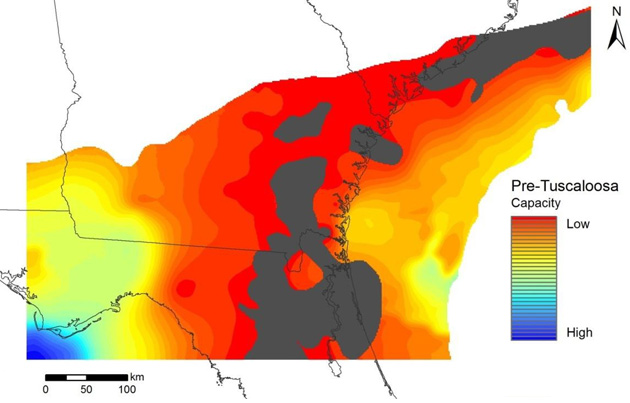
The total capacity for the Pre-Tuscaloosa GSU, using an efficiency factor (E) of 2 percent, is ~111 Gt over an area of ~74,000 mi2 (191,000 km2).


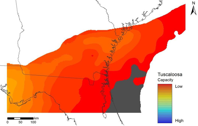
Areas with higher capacity are in offshore portions of the SW and SE GA embayments, which is where the thickest accumulations of permeable sands and highest estimated porosities lie.
Even though the results presented here provide more accurate capacity estimates than previously calculated in the SE US, they still need to be refined by site-level investigations.
The method for calculating capacity (MIT, 2010) is meant to be used for regional assessments without refined estimates of specific intervals into which the CO2 will be injected. For example permeability is not considered so inter-well heterogeneity (connectedness of sands identified in individual wells) is not taken into account.
Maps and cross sections generated during this study are consistent with earlier research results in terms of (1) gross vertical and lateral distribution of major geologic strata and (2) patterns of deposition of sedimentary strata being controlled by the following regional structural features: Southwest Georgia Embayment, Southeast Georgia Embayment, and the Central Georgia uplift/Florida Peninsular arch (referred to by some researchers as the Suwannee Saddle.
Operators of coal- and natural gas-fired power plants, and other types of industrial facilities, that release significant volumes CO2 to the atmosphere have options for GS in the SE US.
To view the entire report, click here.


