Texas Offshore Miocene Project, Task 5
Stratigraphic Containment
We chose three Miocene cores to study in detail: two from Matagorda Island, OCS-G-3733 A-6 (API: 427034015800) and OCS-G-4708 #1 (API: 427034012600), and the other from High Island 24L #9 (API: 427083031600) as shown below.
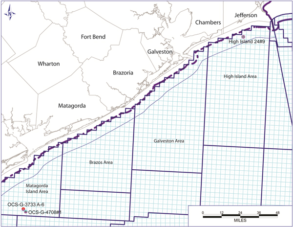
The core of Well OCS-G-3733 A-6 is approximately 200 ft long ranging from 9,100 to 9,212 ft of Early Miocene rock. It contains mainly fine-grained sandstone of delta fringe alternating with muddy siltstone of pro-delta deposits.
The core of Well OCS-G-4708 #1 is from the Lower Miocene interval, ranging from 10,577 to 10,622 ft with poor core recovery (< 50%). The core mainly contains 15 ft of very fine- to fine-grained sandstone overlain by a package of mudstone, siltstone interbedded with fine-grained sandstone.
The Lower Miocene core from High Island 24L #9 extends from 8,401 to 8,761 ft for a total of 106 ft. The top of the core comprises 45 feet of calcareous mudstone and siltstone. It is interpreted as marine shelf deposits. The core contains mainly fissile mudstone and loose sandstones and is preserved in epoxy, which, unfortunately, makes it difficult to generate a detailed core description or take samples for further analyses.
Core samples from well OCS-G-4708#1 show varied capillary entry pressure (i.e., determined by mercury intrusion capillary pressure test). At temperature 270 °F and pressure 4,700 psi, for example, they are capable of retaining a CO2 column of 13 to 243 ft before any intrusion of CO2. Sandstone samples (10607, 10609 and 10590 ft) show the lowest sealing capability. Conversely, homogeneous siltstone samples (10604, 10580, and 10578 ft) have higher sealing capacity. The results suggest that the mudstone interval should have overall desirable sealing capacity.
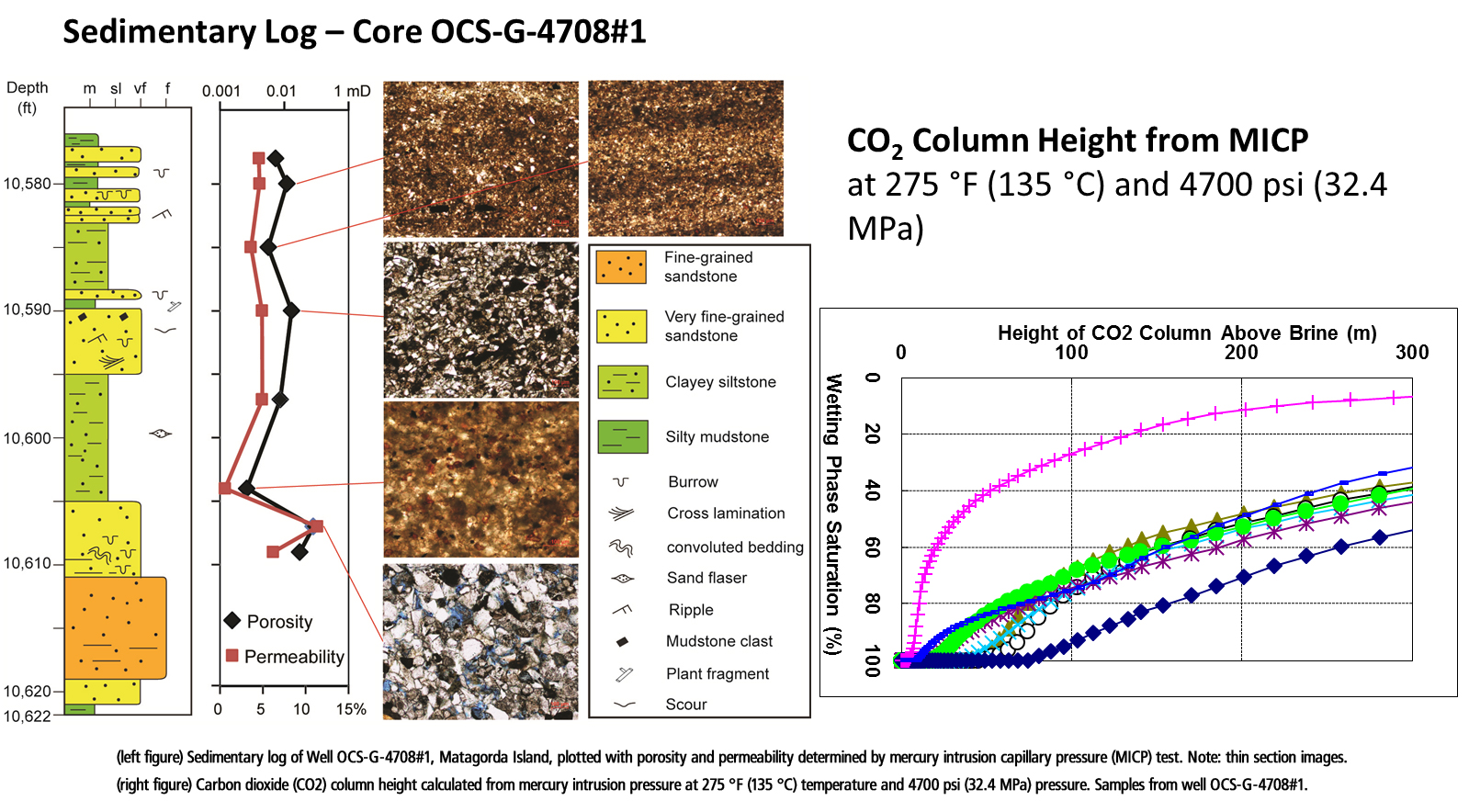
Click image to view larger. (left figure) Sedimentary log of Well OCS-G-4708#1, Matagorda Island, plotted with porosity and permeability determined by mercury intrusion capillary pressure (MICP) test. Note: thin section images.
(right figure) Carbon dioxide (CO2) column height calculated from mercury intrusion pressure at 275°F (135°C) temperature and 4700 psi (32.4 MPa) pressure. Samples from well OCS-G-4708#1.
The image below shows images (a.k.a., “maps”) of thin-sectioned, ion-mill polished core samples analyzed using SEM (scanning electron microscope) with EDX (energy dispersive x-ray). Note the colors in the images, which respectively, relate to specific elements identified in the color bars. The ubiquitous red color indicates an abundance of calcite and its presence partly accounts for the low porosity and permeability of the samples.
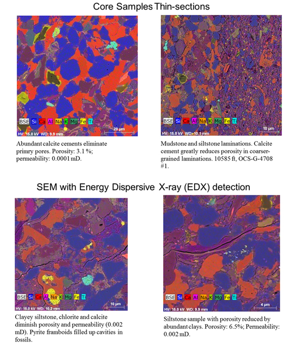
Scanning Electron Microscope (SEM) with Energy Dispersive X-ray (EDX) elemental mapping
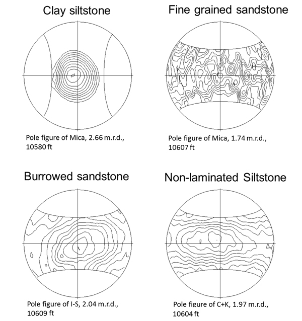
Pole figure diagrams such as those shown below from high-resolution x-ray texture goniometry (HRXTG) analyses visualize the spatial distribution of the x-ray intensities by displaying contour lines representing the pole distribution of phyllosilicate 001plane orientations. More highly aligned fabrics yield pole figures that can be contoured as concentric rings; completely random or isotropic fabrics yield figures that have no poles. The degree of particle alignment is expressed as maximum pole densities in multiples of a random distribution [m.r.d.] (Wenk, 1985), where higher values reflect higher degrees of alignment.
In summary, MICP and HRXTG tests (in addition to other analyses such as x-ray diffraction (XRD) petrography and diagenesis evaluations) indicate good sealing ability in the analyzed samples. However, the paucity of available core samples from Miocene age rocks resulted in seal analyses being restricted to two wells from the Matagorda Island area. To extend the depth and geographic range of our seal study, drill cuttings were selected for petrographic and SEM analyses even though cuttings are inherently an inaccurate gauge of depth provenance. They are, in fact, a mixture of small samples from a diffuse 30+ ft interval penetrated by the drill bit.
We identified fine-grained intervals of Miocene age rock in well logs. Cutting bags from the depth intervals were examined and several larger cutting pieces were selected from each interval. The cuttings pieces were made into one thin section, which was polished for SEM examination. Thin sections were examined using SEM after they were coated with carbon. The analyses were carried out using a field-emission SEM, an FEI Nova NanoSEM 430, at The University of Texas at Austin. Both Secondary Electron (SE) and Back-Scattered Electron modes were used to show mudstone texture. A system of two, energy-dispersive, X-ray detectors was used in conjunction with SEM to produce elemental maps and consequently, help to identify mineral phases. Back-Scattered Electron images and EDS (energy dispersive spectroscopy) elemental maps were obtained from the thin sections, which yield useful information on the texture and lithology of the fine-grained portion of the examined samples as shown below.
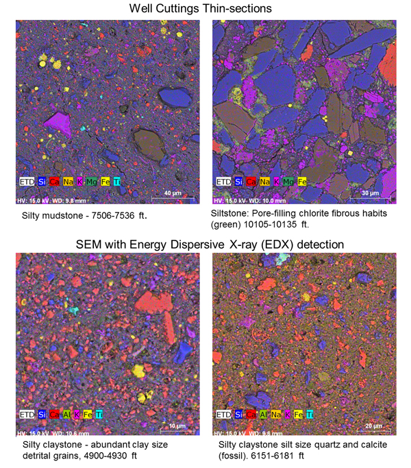
The inspected fine-grained samples show large variations in lithology ranging from claystone, to siltstone, to very fine-grained sandstone. Clay content and fabric alignment also vary within the depth interval. Overall porosity and permeability are estimated to be low and sealing capacity is as high as the previously analyzed core samples from Matagorda Island wells.
Overall, permeability and capillary entry pressure of the cuttings samples are expected to be within the same ranges as the measured confining unit core samples from well OCS-G-4708#1. Though the small volume of the cutting samples prevents XRD mineralogical analysis, SEM assisted with energy dispersive X-ray detectors generates elemental maps of the thin section, which, to a degree, reveals mineralogical distribution. This may be a useful technique for characterization of a specific site (i.e., if no whole core samples are available).
Task 5.1: Modeling
Task 5.2: Caprock Seal Capacity
<< Back to Texas Offshore Miocene Project main page || << view previous Task || view next Task >>


