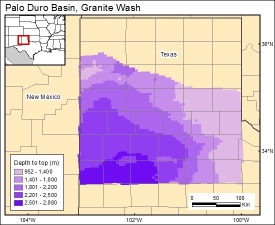
Granite Wash, Palo Duro Basin, Texas (01)
Comments on Geologic Parameters
01 Depth:
We digitized a structure-contour map of the top of the Pennsylvanian section (Budnik and Smith, 1982). Strictly speaking this is not equivalent to the top of the Granite Wash because Granite Wash deposition diminished but continued until the end of the Wolfcampian, the early part of the Permian. The top of the Pennsylvanian map is a close approximation of a top of Granite Wash structural map. We gridded the top structure map, subtracted it from land surface elevation (National Imagery and Mapping Agency, 2000) to calculate gridded depth to Granite Wash (c1granitewash).
01 Map:

01 Reference:
Budnik, R., and Smith, D., 1982, Regional stratigraphic framework of the Texas Panhandle, in Gustavson, T. C., Bassett, R. L., Budnik, R., Finley, R., Goldstein, A. G., McGowen, J. H., Roedder, E., Ruppel, S. C., Baumgardner, R. W., Jr., Bentley, M. E., Dutton, S. P., Fogg, G. E., Hovorka, S. D., McGookey, D. A., Ramondetta, P. J., Simpkins, W. W., Smith, D., Smith, D. A., Duncan, E. A., Griffin, J. A., Merritt, R. M., and Naiman, E. R., Geology and geohydrology of the Palo Duro Basin, Texas Panhandle: a report on the progress of the nuclear waste isolation feasibility studies, 1981: The University of Texas at Austin, Bureau of Economic Geology, Geological Circular 82-7, p. 38–86.
Dutton, S. P., Goldstein, A. G., and Ruppel, S. C., 1982, Petroleum potential of the Palo Duro Basin, Texas Panhandle: The University of Texas at Austin, Bureau of Economic Geology Report of Investigations No. 123, 87 p.
National Imagery and Mapping Agency, 2000, Digital terrain elevation data (DTED Level 0).


