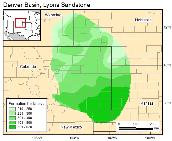
Lyons Sandstone, Denver Basin (03)
Comments on Geologic Parameters
03 Formation Thickness:
Two different maps were found for the Lyons Formation for the north part of the basin. One map was published by Sonnenberg (1981) and one by Levandowski and others (1973). The maps have some discrepancies, so we decided to use the latest because this publication also contains permeability data used in this study. In addition, a map from the south part, published by Garbarini and Veal (1968), was combined with the map from the north part, gridded (c3lyons) and added to the GIS data base. The mapped maximum thickness of the Lyons Sandstone is 300 ft.
03 Map:

03 Reference:
Garbarini, G., and Veal, H. K., 1968, Potential of Denver Basin for disposal of liquid wastes, subsurface disposal in geologic basins-a study of reservoir strata: American Association of Petroleum Geologists Memoir, p. 165-185
Levandowski, D., Kaley, M., and Smalley, R., 1973, Cementation in the Lyons Sandstone and its role in oil accumulation, Denver Basin, Colorado: American Association of Petroleum Geologists Bulletin, v. 57, no. 11, p. 2217-2244.


