Oriskany Formation, Appalachian Basin (04)
Western Pennsylvania, Eastern Ohio, and Eastern Kentucky
Comments on Geologic Parameters
04 Net Sand Thickness:
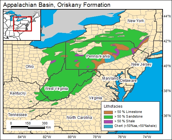
There currently is no published Oriskany Sandstone net-sand-thickness distribution for the region, although there are numerous reports showing local sand-thickness distribution (related to hydrocarbon exploration). There are numerous geophysical logs available for the Oriskany Sandstone interval, from which net-sand-thickness distribution can be accurately mapped (Asquith, 1982). Diecchio and others (1984; their fig. 4) presented a map showing general distribution of lithologies (>50 percent sand, >50 percent shale, >50 percent limestone) and formation thickness for the Oriskany Sandstone horizon; their map was used to characterize net sand thickness.
04 Map:

04 Reference:
Asquith, G., 1982, Basic well log analysis for geologists: Tulsa, American Association of Petroleum Geologists, 216 p.
Diecchio, R. J., Jones, S. E., and Dennison, J. M., 1984, Oriskany Sandstone regional stratigraphic relationships and production trends: West Virginia Geological and Economic Survey Map WV-17, 8 plates.


