Oriskany Formation, Appalachian Basin (05)
Western Pennsylvania, Eastern Ohio, and Eastern Kentucky
Comments on Geologic Parameters
05 Percent Shale:
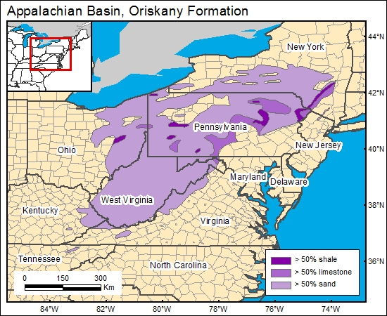
There currently is no published Oriskany Sandstone percent-shale distribution for the region, although there are numerous reports showing local sand thickness and percentage distribution (related to natural gas exploration). There are numerous geophysical logs available for the Oriskany Sandstone interval from which percent shale can be accurately mapped (Asquith, 1982). Diecchio and others (1984; their fig. 4) presented a map showing general distribution of lithologies (>50 percent sand, >50 percent shale, >50 percent limestone) and formation thickness for the Oriskany Sandstone horizon; their map was used to characterize shale content.
05 Map:
05 Reference:
Asquith, G., 1982, Basic well log analysis for geologists: Tulsa, American Association of Petroleum Geologists, 216 p.
Diecchio, R. J., Jones, S. E., and Dennison, J. M., 1984, Oriskany Sandstone regional stratigraphic relationships and production trends: West Virginia Geological and Economic Survey Map WV-17, 8 plates.


