SACROC Research Project: Hydrogeological Analysis of Subsurface Geology
As a first step to evaluating the impact of carbon dioxide (CO2) injection to the drinking water resources overlying SACROC, we performed an analysis of the subsurface geology of the region surrounding SACROC. Water wells in the region vary in depth from only 50 ft to as deep as 500 ft. They also produce different volumes of water. For example, we identified windmills that pump only 5-10 gallons of water per minute and irrigation wells that produce over 250 gallons per minute. This indicated to us that the different types of wells tap into different water-bearing units within the Dockum aquifer.

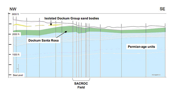
A transect based on geophysical logs through Scurry County shows that there is a continuous Dockum Santa Rosa formation as well as isolated Dockum Group sand bodies that supply fresh water to the region.
The transect in the figure above was assembled by interpreting geophysical logs borrowed from the Texas Commission on Environmental Quality (TCEQ) Surface Casing Division. Log data locations are shown with vertical black lines. The transect crosses Scurry County from the northwest to the southeast through the SACROC oil field, which is located in about the center of the transect as indicated on the bottom of the image. The land surface elevation is shown in the black wavy line across the top of the transect. Notice that the surface is between 2,000 and 3,000 feet above sea level and that the logs extend below the surface to about sea level. CO2 injection takes place about 6,500 feet below land surface or 3,000 ft below sea level, which is way below the deepest level indicated on this cross section.
The pale blue region indicates a group of upper Permian geological formations. These formations contain salty water or brine and hence are not sources of drinking water. The green region is a laterally continuous subunit of the Dockum aquifer called the Dockum Santa Rosa Formation. Most of the water wells in Scurry County extend in the Dockum Santa Rosa unit of the Dockum aquifer and this geological formation provides the largest volume of freshwater in Scurry County. However the water produce from these wells is not necessarily the highest quality water. The yellow indicates isolated Dockum Group sand bodies. They are also a source of freshwater for the region. A third source of drinking water that overlies the Dockum is the Ogallala Formation. Very few of the geophysical logs cover the shallow subsurface interval between the surface and ~100ft depth, hence the Ogallala is not shown in this figure. This geological formation supplies the best quality of drinking water in Scurry County but is not available in very large quantities.
Some water wells draw solely from the shallowest Ogallala formation. Others draw from the yellow isolated Dockum sands or the green Dockum Santa Rosa formation. However, most of the water wells near SACROC draw from some combination of the multiple water-bearing formations. This heterogeneous sourcing of freshwater represents an important complexity in the hydrochemistry of the drinking water in the groundwater system.
Hydrogeological and hydrochemical results from the SACROC groundwater study


