SACROC Research Project: Introduction
The groundwater system in the vicinity of SACROC is complex, with numerous potential sources of carbon dioxide observed in groundwater.
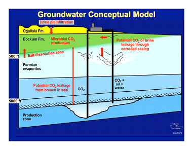
Because of its long history of EOR, the SACROC oilfield is an excellent natural laboratory for studying the effects of deep carbon dioxide injection on the shallow subsurface. On the other hand, the region is geologically complex and hydrologically dynamic as indicated in the figure below. Developing an accurate understanding of the impacts of carbon dioxide injection on groundwater therefore requires an understanding of both the physical hydrogeology and the hydrochemistry in the vicinity of SACROC. These two research components contribute both individually and collectively to our analysis.
The two major objectives of the SACROC groundwater study are:
- To determine if the roughly 37-year history of carbon dioxide injection at SACROC has impacted potable water resources.
- To determine whether injected carbon dioxide can be detected in shallow groundwater.
In the vicinity of the SACROC oilfield, the Dockum aquifer is the primary source of water supply, which includes drinking water, irrigation water, water for livestock, etc. As shown in the figure below the Dockum aquifer, which extends throughout most of Scurry County, also resides above the SACROC oilfield.
The map below also indicates the locations from which monitoring data used in this study were collected.
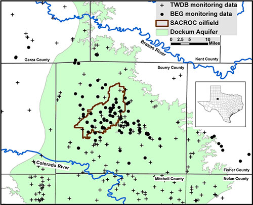
Locations of SACROC oilfield and Dockum Aquifer in Scurry County, Texas. Monitoring points used in the study lie both within and outside of SACROC. The inset box on the right shows the location of Scurry County in northwest Texas.
Locations of SACROC oilfield and Dockum Aquifer in Scurry County, Texas. Monitoring points used in the study lie both within and outside of SACROC. The inset box on the right shows the location of Scurry County in northwest Texas.
In order to understand the hydrogeology of the Dockum aquifer in Scurry and surrounding counties, BEG measured water levels in 38 private water wells between March and November 2008. We augmented this dataset with water level data from 27 additional wells measured by the Texas Water Development Board (TWDB) in November and December 2008.
In order to understand the groundwater chemistry of the region, we collected groundwater samples from 59 wells and one spring during multiple sampling trips between June 2006 and July 2008. Chemical analyses of these samples were conducted at Los Alamos National Laboratory and UT Austin Department of Geological Sciences.
Hydrogeological and hydrochemical results from the SACROC groundwater study


