SACROC Research Project: Analysis of Reservoir Water Levels
Understanding the elevation and horizontal direction of groundwater flow is an important tool for assessing the impact of carbon dioxide on drinking water in and around SACROC oilfield. To accomplish this task, we constructed a potentiometric surface map of the region using measurements of the water level from 65 water wells both inside and outside the boundaries of SACROC oilfield.
Water level data is distinct from the water level of the aquifer itself. In confined aquifers, such as the Dockum aquifer in our study, underground forces exert pressure on the water in the aquifer. When a well is drilled into the aquifer, it provides a pathway through which the water can move. The water rises in the well until it reaches a level where the downward force of gravity balances the upward force from pressure on the aquifer. This is the water level measured in our analysis. When water levels are collected and mapped, the result is a potentiometric surface map that indicates the path of groundwater flow.

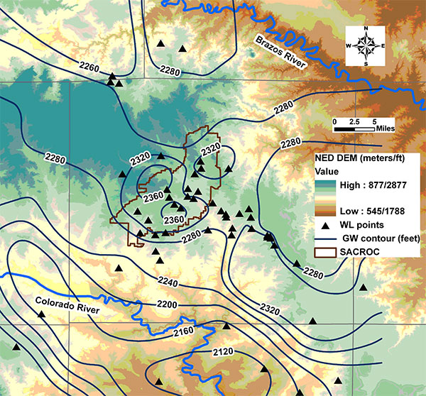
The blue contours on this map show that the potentiometric surface of the Dockum Santa Rosa aquifer is higher in the vicinity of SACROC than in the surrounding areas. Click map to view full-sized.
The figure above shows the potentiometric map we developed for the region within and surrounding SACROC oilfield. The triangles represent the 65 water well locations from which we used water level. We used water level measurements only from wells that extend into the Dockum Santa Rosa subunit of the Dockum reservoir, which supplies the majority of the freshwater to Scurry County. (For discussion of the subsurface geology, click here.) The potentiometric contours of groundwater levels that resulted from our analysis are shown in blue lines.
The colors on the map show the land surface elevation of Scurry County presented in the form of a digital elevation map (DEM), which is available on-line via the National Elevation Dataset (NED) program of the U.S. Geological Survey. Higher elevations are shown in cool colors (turquoise) and lower elevations in warm colors (rust). SACROC lies across an expanse of higher elevation land running from the northwest to the southeast, which may be a partial explanation of why the water level elevations are higher there.
The elevation potential of the groundwater is higher in the vicinity of SACROC than in the surrounding area. Water moves from higher to lower potential, which is a combination of both gravity and pressure, so we would expect the groundwater overlying SACROC to move outward into the surrounding regions. Even though this rate of groundwater flow is very slow, any chemical analysis of water needs to recognize this potential movement of groundwater away from SACROC.
Hydrogeological and hydrochemical results from the SACROC groundwater study


