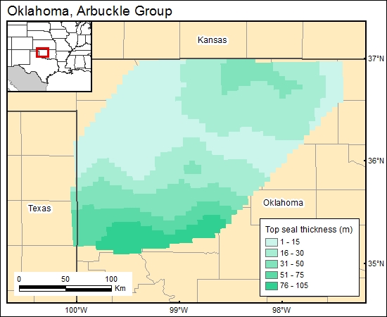
Arbuckle Group, Oklahoma (07)
Comments on Geologic Parameters
07 Top Seal Thickness:
We combined the isopach maps of Hester and Schmoker (1993) and Amsden (1975) to derive a thickness map for the Woodford Shale—the unit that we identify as the best potential seal for the Arbuckle—and gridded it (s7arbuckle). Johnson (1991b) mentioned that by the early 1990's all ten of the hazardous waste-disposal wells then operating in Oklahoma were using the Arbuckle or Arbuckle-Simpson as the recipient reservoir. Significantly, either the Woodford Shale (in the Tulsa area) or truncating Pennsylvanian-age shales (in the Oklahoma City area) acted as the confining units. This fact suggests that, at least in the cases where hazardous waste is involved, the intervening Silurian- and Devonian-age rocks may not be sufficiently low in permeability to act as seals for either the Arbuckle or the Simpson.
07 Map:

07 Reference:
Amsden, T. W., 1975, Panel 4—Isopach map of Woodford Shale, in Hunton Group (late Ordovician, Silurian, and early Devonian) in the Anadarko Basin of Oklahoma: Oklahoma Geological Survey Bulletin, v. 121, 214 p.
Hester, T. C., and Schmoker, J. W., 1993, Regional geology of the Woodford Shale—Anadarko Basin, Oklahoma: an overview of relevance to horizontal drilling, in Johnson, K. S., and Campbell, J. A., eds., Petroleum—reservoir geology in the southern Midcontinent, 1991 Symposium: Oklahoma Geological Survey, Circular 95, p. 74–81.
Johnson, K. S., 1991b, Geologic overview and economic importance of Late Cambrian and Ordovician age rocks in Oklahoma, in Johnson, K. S., ed., Late Cambrian-Ordovician geology of the southern Midcontinent, 1989 Symposium: Oklahoma Geological Survey, Circular 92, p. 3–14.


