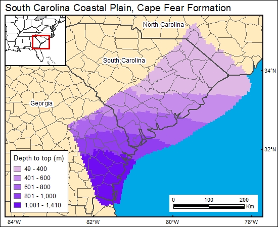
Cape Fear Formation, South Carolina Coastal Plain (01)
Comments on Geologic Parameters
01 Depth:
A number of maps show the elevation at the top of the Cape Fear Formation (Brown and others, 1979; Colquhoun and others, 1983; Aucott and others, 1987; Renkin and others, 1989; Miller, 1990). We chose to use the maps of Renkin and others (1989) because they provided a detailed, regional map of the top of the Cape Fear aquifer, and they clearly documented the stratigraphic position of the top of the unit. We then used a DEM generated from Digital Terrain Elevation Data (National Imagery and Mapping Agency, 2000) to calculate and grid (c1capefear) the depth to top of the Cape Fear brine formation.
01 Map:

01 Reference:
Aucott, W. R., Davis, M. E., and Speiran, G. K., 1987, Geohydrologic framework of the Coastal Plain aquifers of South Carolina: U.S. Geological Survey, Water-Resources Investigations Report 85-4271, 7 sheets.
Brown, P. M., Brown, D. L., Reid, M. S., and Lloyd, O. B., Jr., 1979, Evaluation of the geologic and hydrologic factors related to the water-storage potential of Mesozoic aquifers in the southern part of the Atlantic coastal plain, South Carolina and Georgia: U.S. Geological Survey, Professional Paper 1088, 37 p., 11 plates.
Colquhoun, D. J., Woollen, L. D., Van Nienwenhuise, D. S., Padgett, G. G., Oldham, R. W., Boylan, D. C., Bishop, J. W., and Howell, P. D., 1983, Surface and subsurface stratigraphy, structure and aquifers of the South Carolina Coastal Plain: Columbia, SC, State of South Carolina, Office of the Governor, 78 p.
Miller, J. A., 1990, Ground water atlas of the United States—segment 6, Alabama, Florida, Georgia, and South Carolina: U.S. Geological Survey Hydrologic Investigations Atlas No. HA-730-G, 28 p.
Renkin, R. A., Mahon, G. L., and Davis, M. E., 1989, Hydrogeology of clastic Tertiary and Cretaceous regional aquifers and confining units in the southeastern coastal plain aquifer system of the United States: U.S. Geological Survey Hydrologic Investigations Atlas HA-701, 3 sheets.


