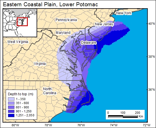
Lower Potomac Group, Eastern Coastal Plain (01)
Comments on Geologic Parameters
01 Depth:
A number of maps show the elevation at the top of the Potomac aquifer (Gill and Farlekas, 1969; Brown and others, 1972; Trapp and Meisler (1992; Trapp, 1992). We chose to use the map of Trapp and Meissler (1992; their plate 7B) because it covers the entire region and clearly defines the hydrostratigraphic unit. We then used a DEM generated from Digital Terrain Elevation Data (National Imagery and Mapping Agency, 2000) to calculate and grid the depth to top of the Potomac brine formation (c1potomac).
01 Map:

01 Reference:
Brown, P. M., Miller, J. A., and Swain, F. M., 1972, Structural and stratigraphic framework, and spatial distribution of permeability of the Atlantic coastal plain, North Carolina to New York: U.S. Geological Survey, Professional Paper 796, 79 p, 59 plates.
Gill, H. E., and Farlekas, G. M., 1969, Geohydrologic maps of the Potomac-Raritan-Magoth aquifer system in the New Jersey coastal plain: U.S. Geological Survey, Hydrologic Investigations Atlas HA-557, 2 sheets
National Imagery and Mapping Agency, 2000, Digital terrain elevation data (DTED Level 0).
Trapp, H., Jr., 1992, Hydrogeologic framework of the northern Atlantic coastal plain in parts of North Carolina, Virginia, Maryland, Delaware, New Jersey, and New York: U.S. Geological Survey Professional Paper 1404-G, 59 p., 13 plates.
Trapp, H., Jr., and Meisler, H., 1992, The regional aquifer underlying the northern Atlantic coastal plain in parts of North Carolina, Virginia, Maryland, Delaware, New Jersey, and New York-summary: U.S. Geological Survey, Professional Paper 1404A, 33 p., 11 plates.


