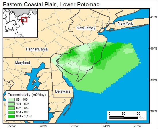
Lower Potomac Group, Eastern Coastal Plain (02)
Comments on Geologic Parameters
02 Permeability/Hydraulic Conductivity:
A number of studies provide information on lower Potomac aquifer permeability or hydraulic conductivity (Hansen, 1969, 1984; Trapp and others, 1984; Trapp, 1992; Leahy and Martin, 1993; Pope and Gordon, 1999). However, only Pope and Gordon (1999) provided a map showing distribution of hydraulic conductivity (transmissivity) for the eastern coastal plain, and it is used for the GIS. The Pope and Gordon (1999) map is limited to the New Jersey coastal plain, and so another data point available from the Waste Gate Formation of eastern Maryland (Hansen, 1984) is also included in the GIS.
02 Map:

02 Reference:
Hansen, H. J., 1969, Depositional environments of subsurface Potomac Group in southern Maryland: American Association of Petroleum Geologists Bulletin, v. 53, p. 1923–1937. ___________ 1984, Hydrogeologic characteristics of the Waste Gate Formation, a new subsurface unit of the Potomac Group underlying the eastern Delmarva Peninsula: Maryland Geological Survey Information Circular 39, 22
Leahy, P. P., and Martin, Mary, 1993, Geohydrology and simulation of ground-water flow in the Northern Atlantic Coastal Plain aquifer system: U.S. Geological Survey Professional Paper 1404-K, 81 p.
Pope, D. A., and Gordon, A. D., 1999, Simulation of ground-water flow and movement of the freshwater-saltwater interface in the New Jersey coastal plain: U.S. Geological Survey Water-Resources Investigations Report 98-4216, 159 p.
Trapp, H., Jr., 1992, Hydrogeologic framework of the northern Atlantic coastal plain in parts of North Carolina, Virginia, Maryland, Delaware, New Jersey, and New York: U.S. Geological Survey Professional Paper 1404-G, 59 p., 13 plates.
Trapp, H., Jr., Knobel, L. L., Meisler, H., and Leahy, P. P., 1984, Test well DO-CE 88 at Cambridge, Dorchester County, Maryland: U.S. Geological Survey, Water-Supply Paper 2229, 48 p.


