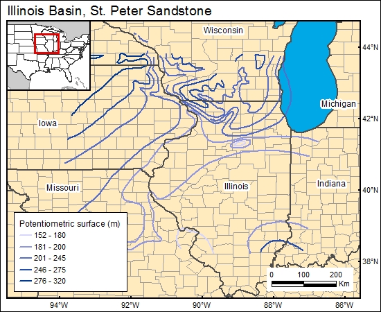
St. Peter Sandstone, Illinois Basin (11)
Comments on Geologic Parameters
11 Flow Direction:
Mandle and Kontis (1992) and Young (1992a, b) provided the most comprehensive map of ground-water flow in the St. Peter-Prairie du Chien-Jordon aquifer in the region. Although their map does not explicitly cover south Illinois and western Kentucky, it clearly indicates that ground-water flow is downdip. Currently, ground-water flow in St. Peter Sandstone in the deepest portions of the basin is not well understood.
11 Map:

11 Reference:
Mandle, R. J., and Kontis, A. L., 1992, Simulation of regional ground-water flow in the Cambrian-Ordovician aquifer system in the northern Midwest, United States: U.S. Geological Survey, Professional Paper 1405-C.
Young, H. L., 1992a, Summary of ground water hydrology of the Cambrian-Ordovician aquifer system in the northern Midwest, United States: U.S. Geological Survey, Professional Paper 1405-A, 55 p.
___________ 1992b, Hydrogeology of the Cambrian-Ordovician aquifer system in the northern Midwest, United States: U.S. Geological Survey, Professional Paper 1405-B, 99 p.


